| Enduring Understanding | Learning Objective | Essential Knowledge |
|---|---|---|
ERT-4 | ERT-4.A |
|
Earth Systems and Resources
AP Environmental Science · Topic 4
 7:28
Earth Systems and Resources
Two towns, forty kilometres apart, on opposite sides of one mountain range. One of them gets three metres of rain a year — a rainforest. The other gets less…
English narration · English + 中文 subtitles burned in
4.1
Plate Tectonics
Syllabus
Source: College Board AP Course and Exam Description
On 26 December 2004 the sea floor off Sumatra jumped upward by several metres. The earthquake lasted almost ten minutes, and the tsunami it raised killed about 230,000 people in fourteen countries. It happened where one plate slides under another. This unit is about the physical Earth that every ecosystem sits on: its moving plates, its soil, its air, its winds and water, and the sunlight that drives them.
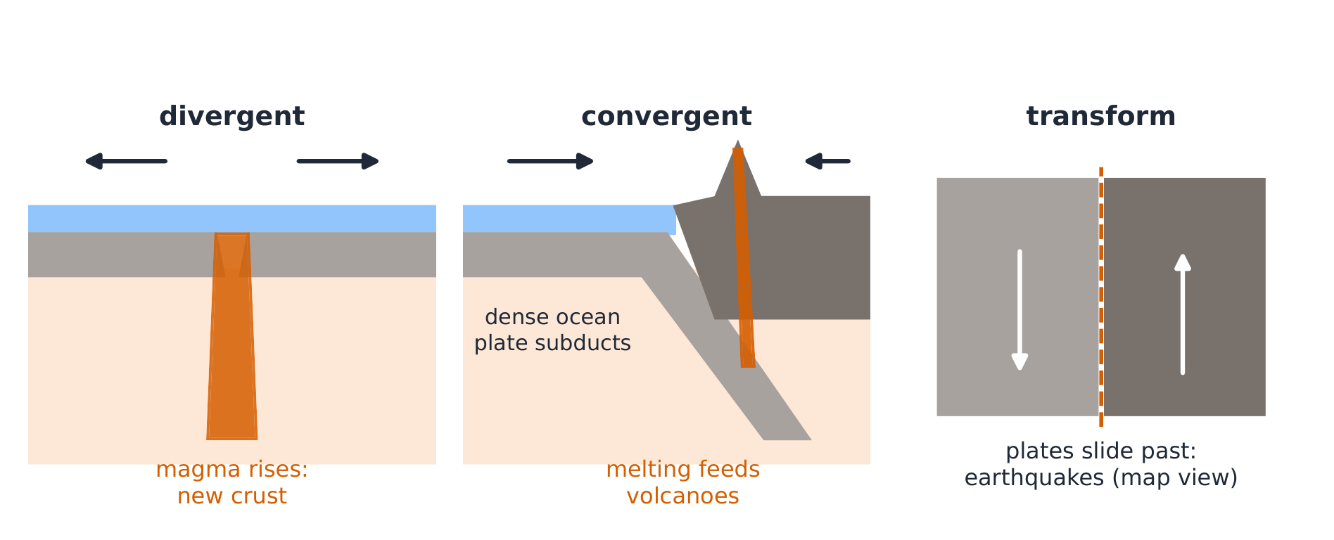
Earth's outer layer (the lithosphere 岩石圈) is broken into rigid plates 板块 that move a few centimetres a year on the hot, slowly flowing mantle below. This is plate tectonics 板块构造. Most earthquakes and volcanoes happen at the edges of plates, the plate boundaries 板块边界.
| Boundary | Plate motion | What forms |
|---|---|---|
| Divergent 离散型 | plates move apart | seafloor spreading, rift valleys, volcanoes, earthquakes |
| Convergent 汇聚型 | plates move together | mountains, island arcs, trenches, volcanoes, earthquakes |
| Transform 转换型 | plates slide past each other | earthquakes |
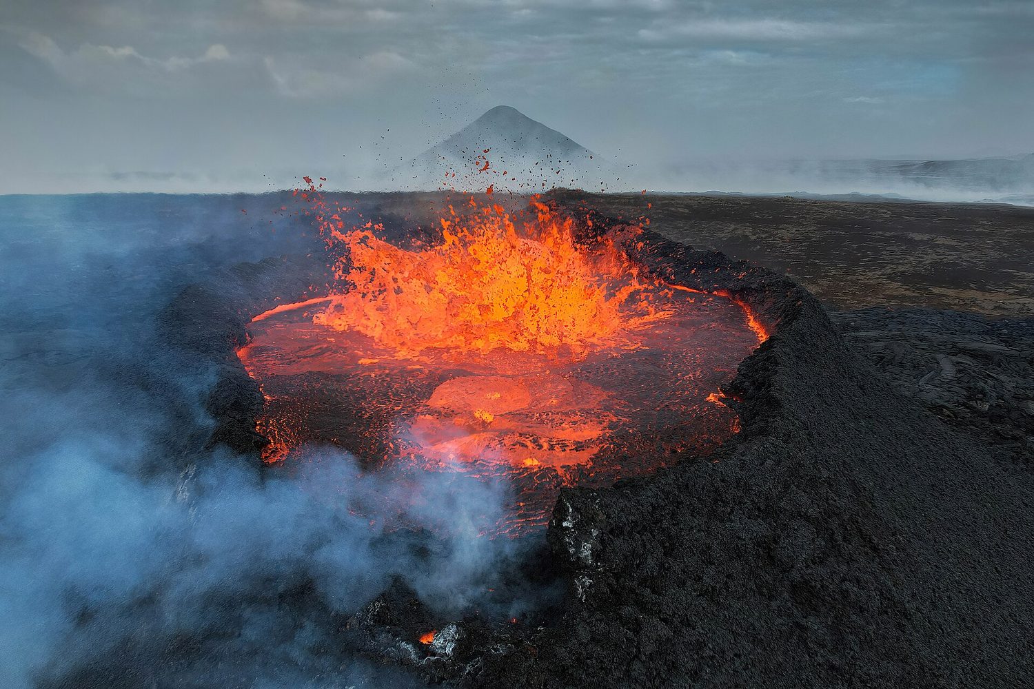
- Divergent: magma rises into the gap and cools into new crust. On the ocean floor this is seafloor spreading (the Mid-Atlantic Ridge); on land it makes a rift valley (East Africa). Iceland sits on the Mid-Atlantic Ridge.
- Convergent: when an ocean plate meets a continental plate, the denser ocean plate sinks under it. This is subduction 俯冲. As the sinking plate goes deep, water released from it lowers the melting point of the mantle rock above, which melts; the magma rises to form volcanoes (the Andes). When two ocean plates meet, subduction forms a chain of volcanic islands, an island arc (Japan, the Philippines). When two continents meet, neither sinks, so the crust crumples into high mountains (the Himalayas).
- Transform: the plates grind past each other, like the San Andreas Fault in California.
Why earthquakes happen. Between earthquakes, friction locks the two sides of a fault 断层 together while the plates keep moving, so stress builds up in the rock. When the stress overcomes the friction, the fault slips suddenly and the stored energy is released as an earthquake.
Hot spots 热点 are places where a plume of hot mantle rises under the middle of a plate, as under Hawaii. The plate moves over the fixed hot spot, leaving a line of volcanoes that get older away from the hot spot.
On a map of plate boundaries you can predict where volcanoes, earthquakes, island arcs and faults will be. Plate boundaries bring hazards, but they also bring fertile volcanic soils and mineral deposits.
Worked example (rate). A plate moves 5 cm per year. In 1 million years it moves $5\ \text{cm/yr}\times 10^{6}\ \text{yr}=5\times10^{6}\ \text{cm}$. Convert: $5\times10^{6}\ \text{cm} \div 100 = 5\times10^{4}\ \text{m} = 50\ \text{km}$. Small yearly motions open oceans over geologic time.
Explore
What kind of boundary?
Sort each event by the type of plate boundary that causes it - plates moving apart, together, or sliding past.
Vocabulary
Train
| English |
|---|
| lithosphere |
| plates/pleɪts/ |
| plate tectonics/pleɪt tekˈtɒnɪks/ |
| plate boundaries |
| divergent/daɪˈvɜːdʒənt/ |
| convergent/kənˈvɜːdʒənt/ |
| transform/trænsˈfɔːm/ |
| subduction |
| fault |
| hot spots |
4.2
Soil Formation and Erosion
Syllabus
| Enduring Understanding | Learning Objective | Essential Knowledge |
|---|---|---|
ERT-4 | ERT-4.B |
|
Source: College Board AP Course and Exam Description
Soil 土壤 is a mix of weathered rock, organic matter, water, air and living things. It forms when parent material 母质 (the rock below) is broken down by weathering 风化, then moved and deposited.
- Physical weathering: rock is broken into smaller pieces without changing its chemistry, for example by ice expanding in cracks, roots, or wind and water.
- Chemical weathering: rock is changed by chemical reactions, for example by acid rain dissolving limestone.
- Biological activity: plants, fungi, worms and bacteria add organic matter and mix the soil. Dead matter breaks down into dark humus 腐殖质.
Soil forms very slowly: about 2–3 cm in a few hundred years or more. It forms faster in warm, wet climates, where weathering and decomposition are quicker, and slower in cold or dry places. On a new volcanic landscape, primary succession starts with lichens and mosses, which break down rock and add organic matter until enough soil exists for grasses, then shrubs and trees.
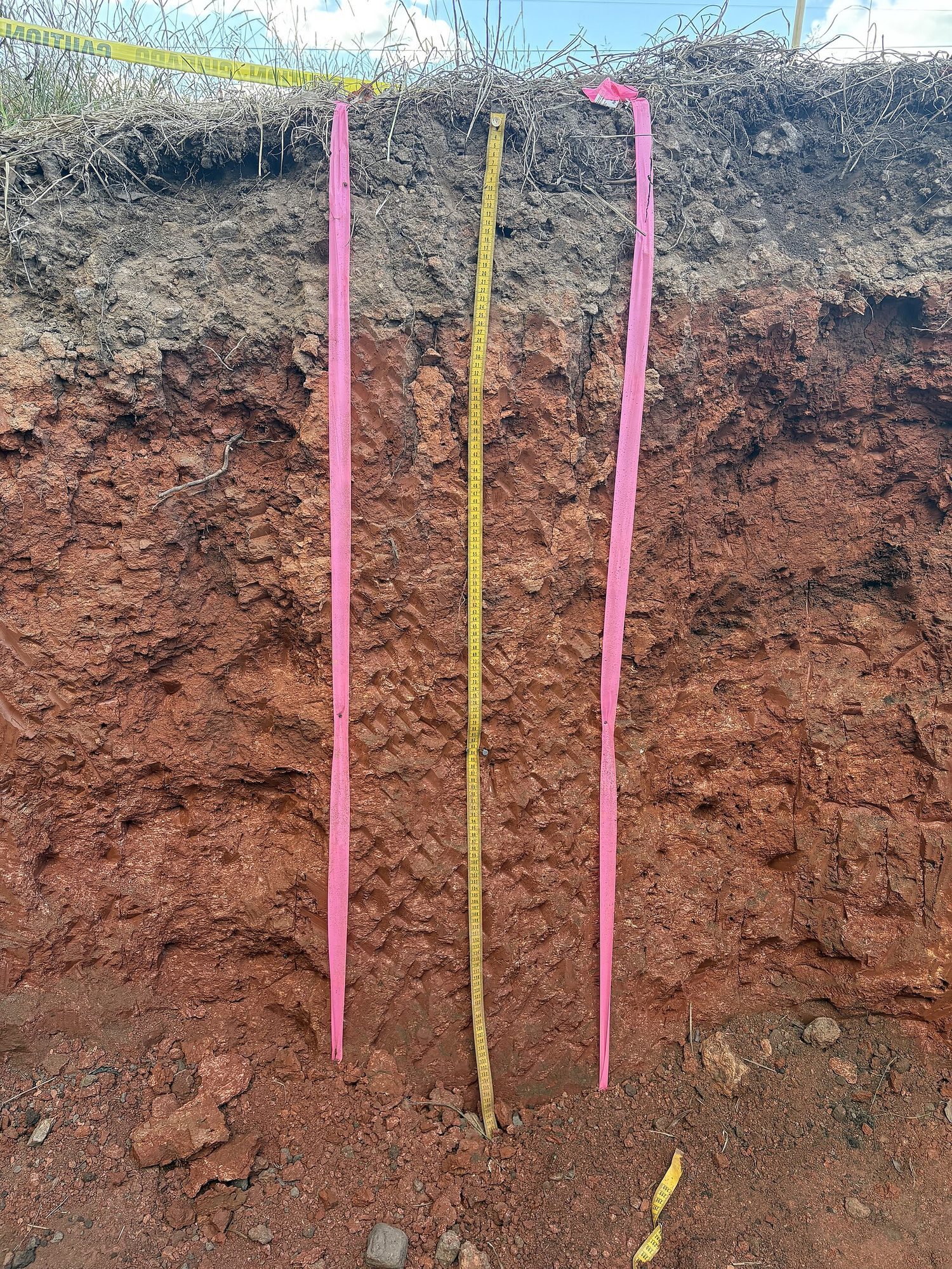
Soil horizons. As soil develops it forms layers called horizons 土层:
| Horizon | Name | Contents |
|---|---|---|
| O | organic layer | leaf litter and partly decomposed matter |
| A | topsoil | humus mixed with minerals; most roots and life |
| B | subsoil | minerals and nutrients washed down from above |
| C | weathered parent material | broken rock |
| R | bedrock | solid rock |
Erosion 侵蚀 is the removal of soil by wind or water. It is natural, but people speed it up by removing plant cover: farming bare fields, cutting forests, overgrazing 过度放牧 and building. Eroded soil ends up in streams as sediment, which makes the water cloudy (high turbidity 浊度), blocks light for water plants and buries fish eggs. Healthy soil also filters and cleans water that moves through it, so protecting soil protects water quality.
Because soil forms far more slowly than it can erode, topsoil lost in a few years may take centuries to replace.
Vocabulary
Train
| English |
|---|
| soil/sɔɪl/ |
| parent material |
| weathering/ˈweðərɪŋ/ |
| humus/ˈhjuːməs/ |
| horizons/həˈraɪznz/ |
| erosion/ɪˈrəʊʒn/ |
| overgrazing/ˌəʊvəˈɡreɪzɪŋ/ |
| turbidity/tɜːˈbɪdɪti/ |
4.3
Soil Composition and Properties
Syllabus
| Enduring Understanding | Learning Objective | Essential Knowledge |
|---|---|---|
ERT-4 | ERT-4.C |
|
Source: College Board AP Course and Exam Description
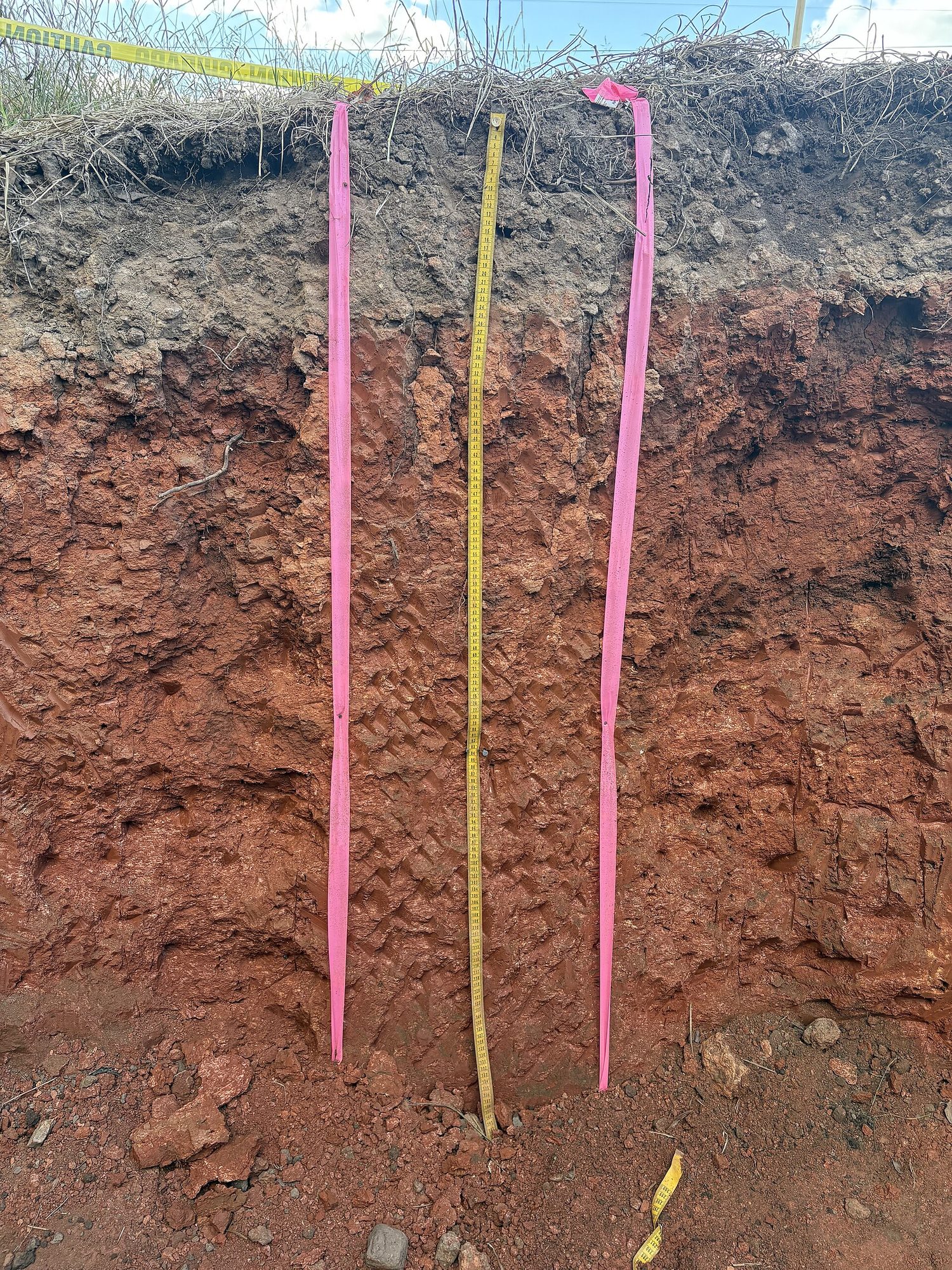
Soil particles are sorted by size into three groups:
| Particle | Size | Feel | Water |
|---|---|---|---|
| Sand | largest (0.05–2 mm) | gritty | drains fast, holds little |
| Silt | medium | smooth like flour | middle |
| Clay | smallest (under 0.002 mm) | sticky when wet | holds a lot, drains slowly |
The mix of sand, silt and clay is the soil's texture 质地. Texture controls three properties:
- Porosity 孔隙度: the fraction of the soil that is empty space.
- Permeability 渗透性: how fast water moves through the soil. Sand has large, connected pores and high permeability; clay has tiny pores and low permeability.
- Water holding capacity 持水能力: the total water the soil can hold. Clay and humus hold the most; sand the least.
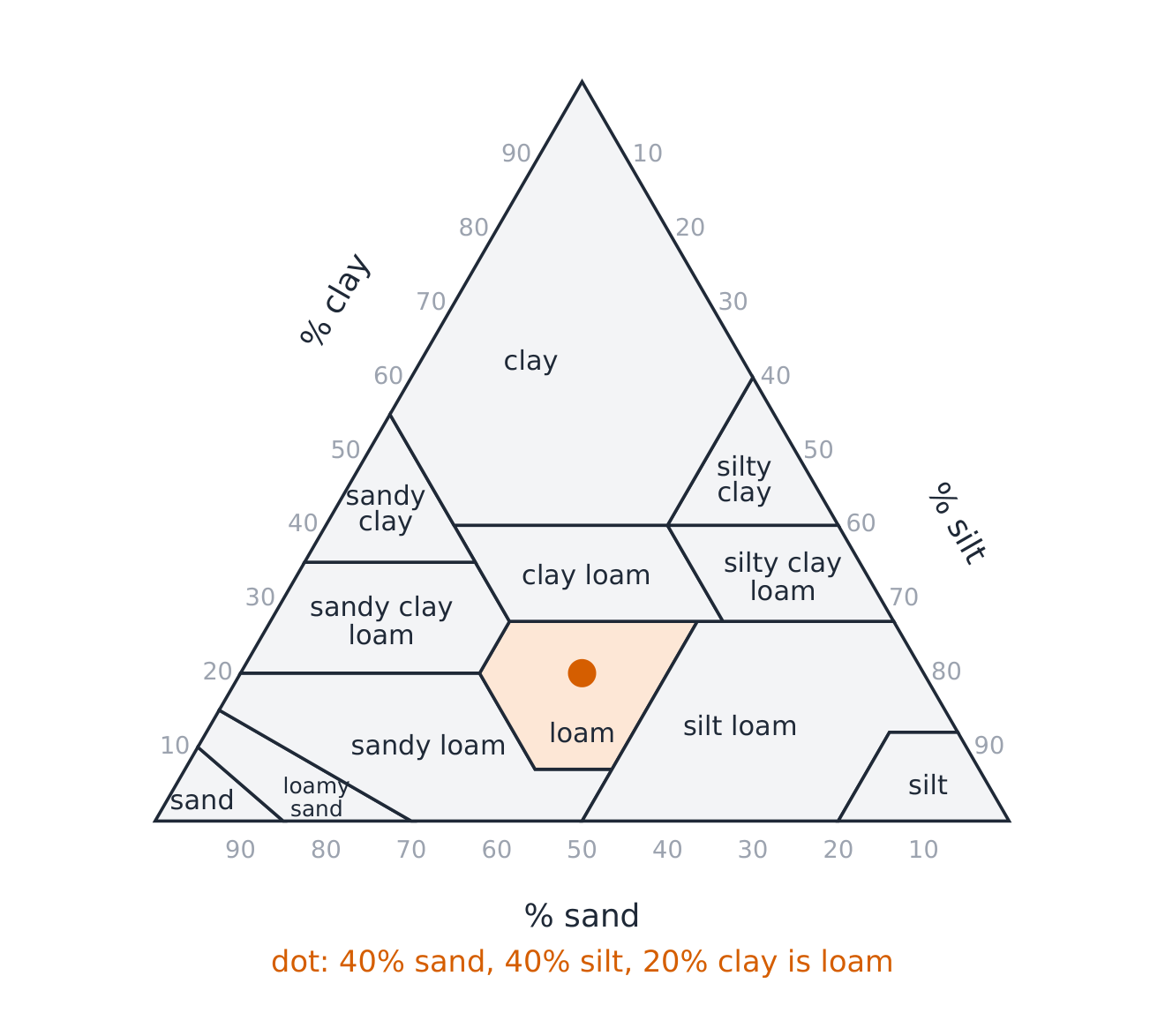
Clay also holds nutrients well, because its tiny particles have a huge surface area. Loam 壤土, a mix of about 40% sand, 40% silt and 20% clay, is best for most plants: it drains well but still holds water and nutrients.
The soil texture triangle. A soil texture triangle 土壤质地三角图 names a soil from its percentages of sand, silt and clay. Find the clay percentage on the left side, the silt on the right side and the sand along the bottom, follow the lines in from each side, and read the class where they meet. The three percentages always add up to 100.
Worked example. A soil sample is 10% sand and 60% clay. The silt is $100 - 10 - 60 = 30\%$. Reading the triangle, the point is in the clay class. It will hold a lot of water but drain slowly, so it may waterlog.
Testing soil. Farmers test soil to decide on irrigation and fertilizer:
- Chemical: pH, and nutrients such as nitrogen, phosphorus and potassium.
- Physical: texture (by settling a sample in a jar of water: sand settles first, then silt, then clay), water holding capacity, and how fast water soaks in.
- Biological: the number of earthworms and microorganisms, and the amount of organic matter.
Explore
Sort the soil particles
Sort each soil particle by its size - the mix of sizes gives a soil its texture and properties.
Vocabulary
Train
| English |
|---|
| texture/ˈtekstʃə/ |
| porosity/pɔːˈrɒsɪti/ |
| permeability/ˌpɜːməˈbɪlɪti/ |
| water holding capacity |
| loam/ləʊm/ |
| soil texture triangle |
4.4
Earth's Atmosphere
Syllabus
| Enduring Understanding | Learning Objective | Essential Knowledge |
|---|---|---|
ERT-4 | ERT-4.D |
|
Source: College Board AP Course and Exam Description
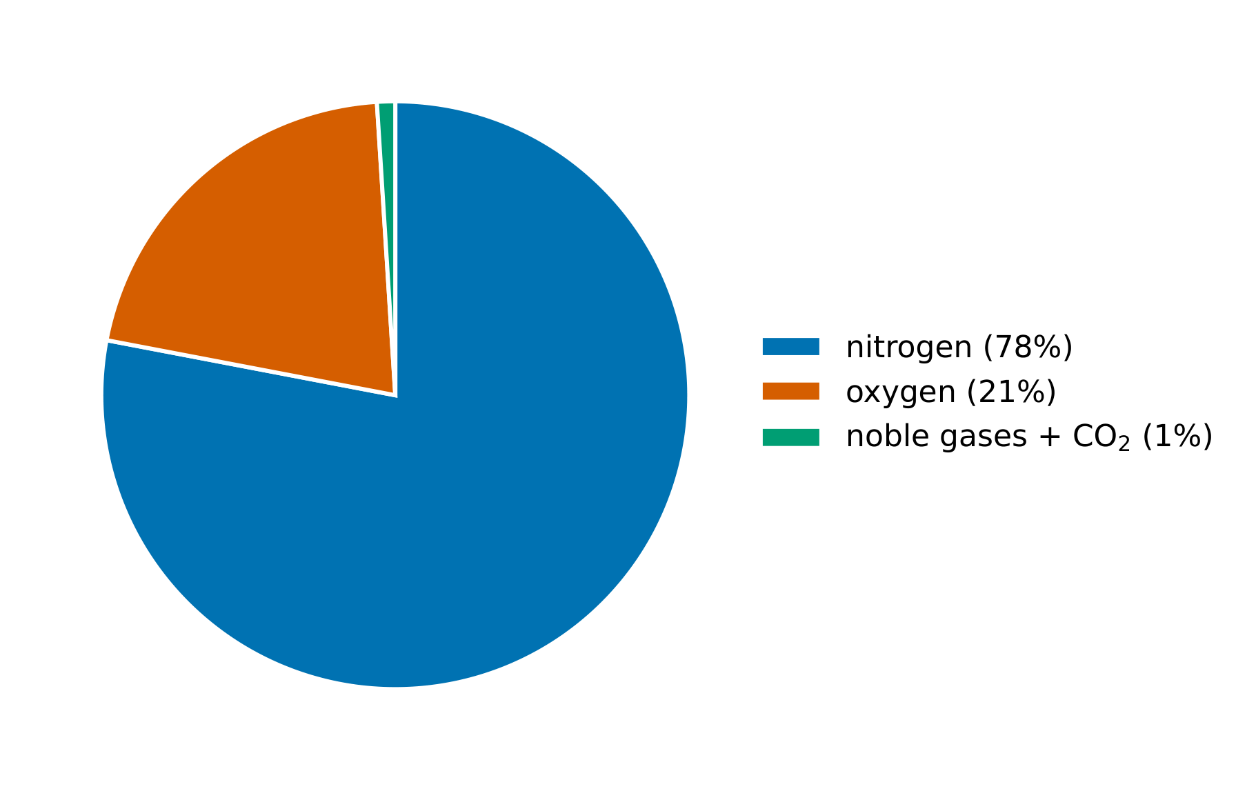
The atmosphere 大气层 is the layer of gases around the Earth. Dry air is about 78% nitrogen ($\text{N}_2$), 21% oxygen ($\text{O}_2$), 0.93% argon, and about 0.04% carbon dioxide, plus traces of other gases. Water vapour varies from 0 to about 4%. The trace gases are small in amount but large in effect: $\text{CO}_2$, water vapour and methane trap heat (the greenhouse effect).
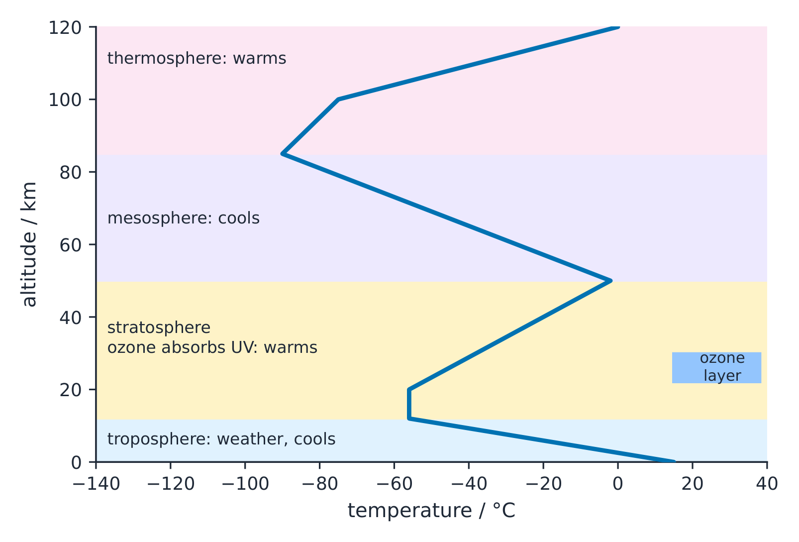
The atmosphere has layers, defined by whether the temperature falls or rises with height:
- Troposphere 对流层 (0 to about 12 km): temperature falls with height. It holds about 75% of the air's mass and almost all the water vapour, so all weather happens here.
- Stratosphere 平流层 (about 12 to 50 km): temperature rises with height, because the ozone layer 臭氧层 here absorbs the Sun's ultraviolet (UV) light. This ozone protects life from harmful UV.
- Mesosphere 中间层 (about 50 to 85 km): temperature falls again; it is the coldest layer. Meteors burn up here.
- Thermosphere 热层 (about 85 to 600 km): temperature rises steeply as gases absorb high-energy solar radiation. The auroras happen here.
- Exosphere 外逸层: the thin outer edge, merging into space.
Explore
Which atmospheric layer?
Sort each feature into the atmospheric layer where it is found.
Vocabulary
Train
| English |
|---|
| atmosphere/ˈætməsfɪə/ |
| troposphere/ˈtrɒpəsfɪə/ |
| stratosphere/ˈstrætəsfɪə/ |
| ozone layer/ˈəʊzəʊn ˈleɪə/ |
| mesosphere |
| thermosphere |
| exosphere |
4.5
Global Wind Patterns

Syllabus
| Enduring Understanding | Learning Objective | Essential Knowledge |
|---|---|---|
ERT-4 | ERT-4.E |
|
Source: College Board AP Course and Exam Description
Global wind patterns 全球风带 are driven by uneven heating. The most intense sunlight arrives at the equator, so the air there is heated most. Warm air is less dense, so it rises. As it rises it cools, and its water vapour condenses and falls as heavy rain: this is why tropical rainforests lie on the equator.
The rising air spreads toward the poles high up, cools, becomes denser and sinks at about 30° north and south. Sinking air warms and is dry, so the world's great deserts (the Sahara, the Australian deserts) lie near 30°. The air then flows back along the surface toward the equator. This loop is a convection cell 对流环流, the Hadley cell. Two more cells (Ferrel and polar) carry the pattern to the poles, with rising air (rain) at about 60° and sinking air (dry) at the poles.
Because the Earth spins, moving air is deflected: to the right in the Northern Hemisphere and to the left in the Southern Hemisphere. This is the Coriolis effect 科里奥利效应. It turns the surface winds into the prevailing winds 盛行风:
- Trade winds 信风 (0–30°): blow from the east toward the equator.
- Westerlies 西风带 (30–60°): blow from the west. They carry weather across the USA from west to east.
- Polar easterlies (60–90°): blow from the east.
Vocabulary
Train
| English |
|---|
| global wind patterns/ˈɡləʊbl wɪnd ˈpætnz/ |
| convection cell |
| Coriolis effect/ˌkɒrɪˈəʊliz ɪˈfekt/ |
| prevailing winds |
| trade winds |
| westerlies |
4.6
Watersheds

Syllabus
| Enduring Understanding | Learning Objective | Essential Knowledge |
|---|---|---|
ERT-4 | ERT-4.F |
|
Source: College Board AP Course and Exam Description
A watershed 流域 (also called a drainage basin) is all the land that drains into one river, lake or other body of water. High ground called a divide 分水岭 separates one watershed from the next. Every watershed is described by its area, length, slope, soil and vegetation.
These features control how water moves:
- Slope: steep slopes make water run off faster, with more erosion and flooding.
- Soil: permeable soils let rain soak in and refill groundwater; clay or paved surfaces increase runoff 径流.
- Vegetation: plant roots hold soil, and leaves slow the rain, so forested watersheds have clean water and steady flow.
Anything on the land ends up downstream: fertilizer from farms, oil from roads, sediment from building sites. So deforesting a watershed raises sediment and turbidity in its streams, and also water temperature (less shade). Natural flooding is useful: when a river floods its floodplain 洪泛区, it deposits fertile sediment and refills wetlands and groundwater.
Removing riverbank vegetation. The strip of trees and plants along a river is its riparian zone. If it is cleared, banks erode faster, so the channel widens and moves; more sediment and nutrients reach the water; and with less shade the water warms and holds less oxygen. Fish that lay eggs in clean gravel lose their spawning sites when sediment covers it.
Worked example (watershed water budget). A watershed delivers an average of 9.60 million acre-feet (maf) of water to a reservoir each year. One maf is $3.26 \times 10^{11}$ gallons, and a household uses $5.0 \times 10^{4}$ gallons a year. How many households could this water supply for a year?
- Convert to gallons: $9.60 \times 3.26 \times 10^{11} \approx 3.13 \times 10^{12}$ gallons.
- Divide by use per household: $\dfrac{3.13 \times 10^{12}}{5.0 \times 10^{4}} \approx 6.3 \times 10^{7}$ households, about 63 million.
- In a drought year when the river flows at only 36% of average, the same water supplies $0.36 \times 63 \approx 23$ million households.
Keep the units on every line, and divide the powers of ten by subtracting exponents ($10^{12} \div 10^{4} = 10^{8}$).
Explore
Inside or outside the watershed?
Sort each idea by whether it correctly describes a watershed.
Vocabulary
Train
| English |
|---|
| watershed/ˈwɔːtəʃed/ |
| divide/dɪˈvaɪd/ |
| runoff/ˈrʌnɒf/ |
| floodplain |
4.7
Solar Radiation and Earth's Seasons
Syllabus
| Enduring Understanding | Learning Objective | Essential Knowledge |
|---|---|---|
ENG-2 | ENG-2.A |
|
Source: College Board AP Course and Exam Description
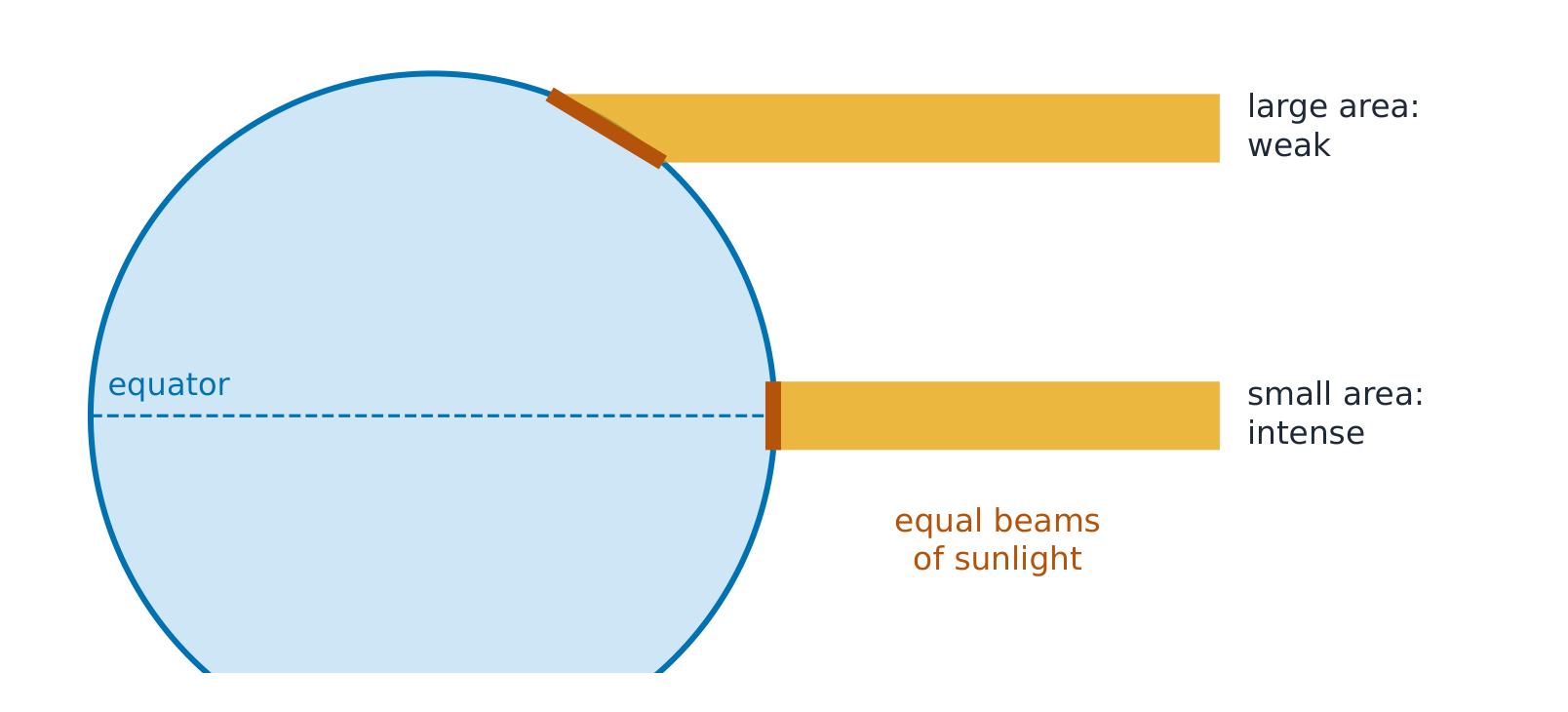
Insolation 日射 (incoming solar radiation) is the Earth's main source of energy. How much a place receives depends on the angle of the Sun's rays. Near the equator, the rays hit the surface almost head-on, so a beam's energy falls on a small area. Near the poles the same beam hits at a low angle and spreads over a much larger area, so each square metre gets less energy. It also passes through more atmosphere. This is why insolation is highest at the equator and falls toward the poles.
Seasons 季节 are caused by the tilt of the Earth's axis 地轴倾斜 (about 23.5°), not by the Earth's distance from the Sun. The axis always points the same way in space. In June the Northern Hemisphere is tilted toward the Sun: the Sun is higher in the sky, its rays are more direct, and the days are longer, so the north has summer. At the same time the Southern Hemisphere is tilted away and has winter. In December the situation reverses.

A place gets the most solar radiation on its longest summer day and the least on its shortest winter day. Near the equator, day length and insolation change little through the year, so there are no strong seasons.
Vocabulary
Train
| English |
|---|
| insolation |
| seasons/ˈsiːznz/ |
| tilt of the Earth's axis |
4.8
Earth's Geography and Climate
Syllabus
| Enduring Understanding | Learning Objective | Essential Knowledge |
|---|---|---|
ENG-2 | ENG-2.B |
|
Source: College Board AP Course and Exam Description
Weather is the condition of the air on a given day; climate 气候 is the average pattern over 30 years or more. Climate depends on the Sun's energy, but also on geography:
- Latitude: higher latitude, less insolation, colder.
- Altitude: air cools by about 6.5 °C for every 1000 m of height, so mountains are colder.
- Oceans: water heats and cools slowly, so coastal places have milder climates than inland places. Ocean currents carry heat: the Gulf Stream keeps western Europe warmer than its latitude suggests.
- Mountains: they block winds and create rain shadows.
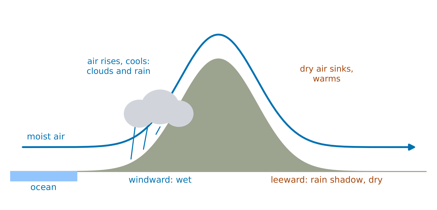
A rain shadow 雨影 forms when moist wind meets a mountain range. The air is forced up the windward 迎风 side, cools, and its water vapour condenses and falls as rain. The air that crosses the top has lost its moisture; it sinks down the leeward 背风 side and warms, so that side is dry. Death Valley in California lies in the rain shadow of the Sierra Nevada.

Explore
What shapes a local climate?
Sort each geographic feature by how it changes a region's climate.
Vocabulary
Train
| English |
|---|
| climate/ˈklaɪmət/ |
| rain shadow/reɪn ˈʃædəʊ/ |
| windward |
| leeward |
4.9
El Nino and La Nina
Syllabus
| Enduring Understanding | Learning Objective | Essential Knowledge |
|---|---|---|
ENG-2 | ENG-2.C |
|
Source: College Board AP Course and Exam Description
El Niño 厄尔尼诺 and La Niña 拉尼娜 are changes in the surface temperature of the tropical Pacific Ocean, and in the winds above it, that recur every few years. Together they are called the El Niño–Southern Oscillation (ENSO).
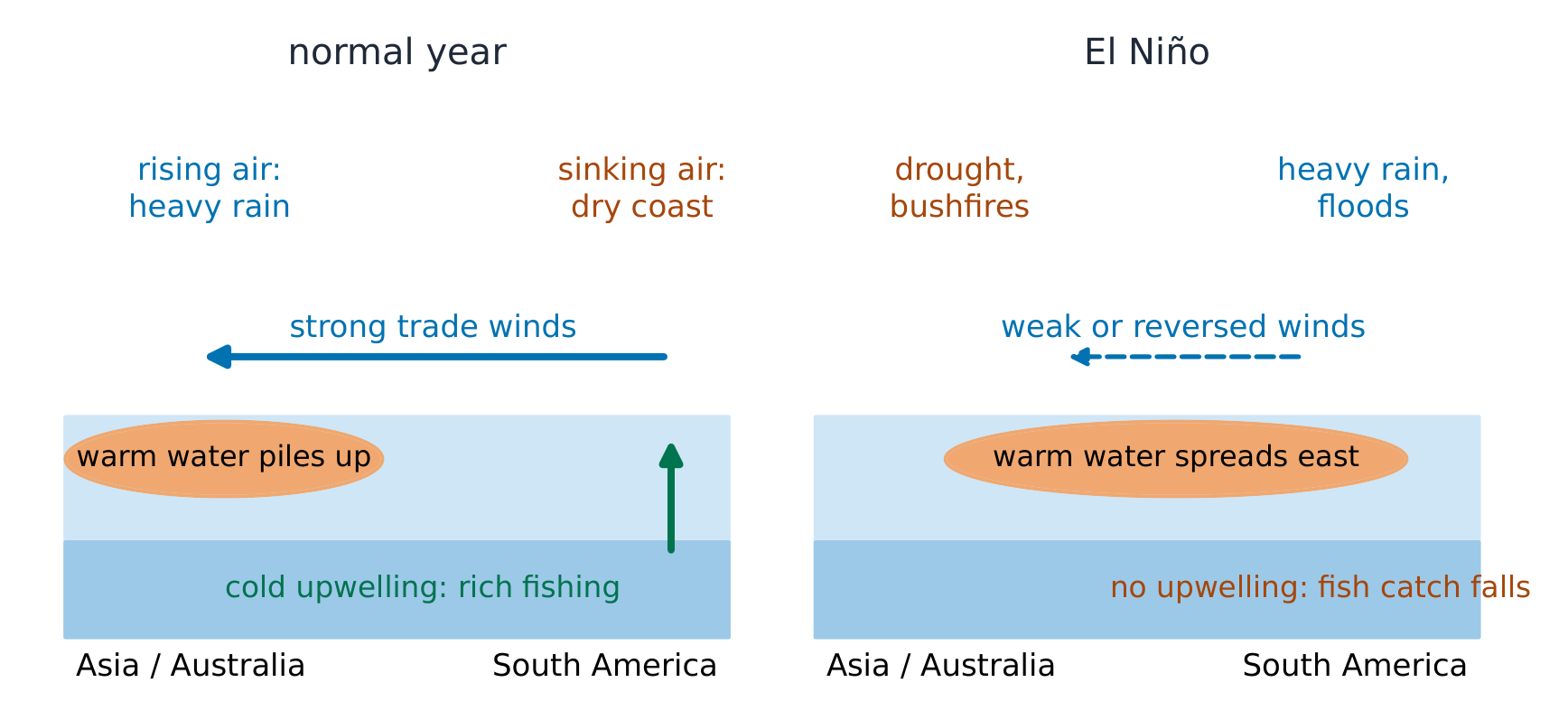
A normal year. Strong trade winds blow from east to west across the Pacific. They push warm surface water west, toward Indonesia and Australia, where the warm water heats the air, which rises and brings heavy rain. Off the coast of Peru, the winds push surface water away, and cold, nutrient-rich water rises from below. This upwelling 上升流 feeds plankton and supports one of the world's richest fisheries.
El Niño. The trade winds weaken or even reverse. Warm water spreads east across the Pacific to South America. Upwelling off Peru stops, so plankton and the fish catch fall. Rain moves east with the warm water: Peru and Ecuador have floods, while Indonesia and Australia have drought and bushfires. The effects spread worldwide: the southern USA usually has a wetter winter.
La Niña is the opposite: the trade winds become stronger than normal, the eastern Pacific becomes cooler than normal, upwelling increases, and the west gets even more rain. The southern USA usually has a drier winter, and Atlantic hurricanes are more common.
The same event affects places differently, depending on where they are and their geography.
Explore
El Nino or La Nina?
Sort each condition by whether it happens during El Nino or La Nina in the Pacific.
Vocabulary
Train
| English |
|---|
| El Niño/el ˈniːnjəʊ/ |
| La Niña/læ ˈniːnjə/ |
| upwelling/ˈʌpwəlɪŋ/ |
4.9
Exam tips
- Match each plate boundary to what it makes: divergent (spreading, rift valleys), convergent (subduction, volcanoes, mountains, island arcs, trenches), transform (earthquakes only).
- To explain subduction volcanoes: the denser plate sinks, melts at depth, and the magma rises.
- Know the soil horizons (O, A, B, C, R) and use the texture triangle: the three percentages add to 100.
- Sand drains fast and holds little water; clay holds a lot but drains slowly; loam is best for crops.
- Atmosphere layers: troposphere (weather), stratosphere (ozone layer absorbs UV, so it warms with height).
- Global winds: rising air at the equator (rain), sinking air at 30° (deserts); the Coriolis effect deflects winds.
- Seasons come from the Earth's tilt, not its distance from the Sun.
- A rain shadow is dry on the leeward side. Say which side gets the rain and why: rising air cools and condenses.
- El Niño: weaker trade winds, warm water moves east, upwelling stops off South America, fisheries decline.
Interactive lessons on this topic
Work through it step by step, with instant-check exercises.