Skip to content

Selected options and fieldwork · Geographic inquiry and sampling

International Baccalaureate · IB Diploma · Geography · SL · Topic 3

Video lesson for this topic Open the video page
10:17

Options and fieldwork

Besides the core, every student studies optional themes: two at standard level, three at higher level, examined in Paper 1. Every student also writes a…

English narration · English + 中文 subtitles burned in

3.1

Options and fieldwork

IB Diploma Programme Geography SL (first assessment 2019; 2017 guide). Besides the core, every student studies optional themes 选修主题: SL students study two of the seven options and HL students three. The options are examined in Paper 1. Every student also writes a fieldwork 野外考察 report on data they collect themselves: the internal assessment 内部评估 (IA). This topic gives each option's key ideas, processes and one case study, and then teaches the fieldwork method from question to conclusion.

In July 2021 more than 600 mm of rain fell on Zhengzhou in three days, close to the city's normal rainfall for a whole year. Water poured into underground train tunnels and roads became rivers. A few months later, coastal towns in England were still arguing about whether to build higher sea walls or let the sea take low farmland. The options study questions like these: how physical processes work, how they affect people, and how people manage them.

Must-know for options and fieldwork:

Area Key content
Paper 1 each option: structured questions (10 marks) and one essay from a choice of two (10 marks)
freshwater drainage basin; storm hydrograph and lag time; hard and soft flood management
coasts wave erosion and deposition; groynes, sea walls, managed realignment
extreme environments glacial and hot-arid processes; opportunity against challenge
hazards plate margins; risk depends on the hazard, exposure and vulnerability
tourism Butler's model; carrying capacity; Venice's controls
food and health famine as a failure of access; the epidemiological transition
urban land-use models; megacities; urban stress and regeneration
fieldwork question, hypothesis, sampling, analysis with $r_s$ or $\chi^2$, evaluation
Vocabulary Train
English
optional theme
fieldwork/ˈfiːldwɜːk/
internal assessment
opportunity/ɒpəˈtjuːnɪti/
3.2

How the options are examined

In Paper 1 each option has 20 marks. The first part is a set of short structured questions 结构化问题 (10 marks), often about a map, graph or table. Then you choose one of two essays (10 marks). SL students answer two options in 1 hour 30 minutes; HL students answer three in 2 hours 15 minutes.

The essays use the command terms examine, discuss, evaluate and to what extent. An essay answer needs a clear view, named examples with specific detail 具体细节 (places, dates, numbers), and a balanced judgement. "Floods are bad for people" earns little; "the 2021 Zhengzhou flood killed 380 people, including 14 passengers trapped in a flooded metro train" earns credit.

Vocabulary Train
English
structured question
specific detail
3.3

Freshwater

A drainage basin 流域 is the area of land that a river and its tributaries drain. Rain that falls on it can be stored (in soil, lakes and groundwater) or move to the river: over the surface (surface runoff 地表径流) or more slowly through the soil and rock.

A storm hydrograph 暴雨水文曲线 shows how a river's discharge 流量 (the volume of water passing a point each second) changes after a storm. Discharge rises along the rising limb 上升段 to a peak 洪峰 and falls along the falling limb. The time from peak rainfall to peak discharge is the lag time 滞后时间.

Schematic rural and urban storm hydrographs with rainfall bars and lag times
The same storm on two basins: the urban one peaks sooner and higher, so its lag time is shorter.

Cities shorten the lag time and raise the peak. Concrete and roofs do not let water soak in, and drains carry it quickly to the river. Steep slopes, saturated soil and a small, round basin have the same effect; forests and gentle slopes slow water down.

Flood management 洪水管理 can be hard or soft:

Type Examples Strengths Weaknesses
hard engineering 硬工程 dams, embankments, straightened channels protects a large area; can also store water and make electricity expensive; changes the river ecosystem; can move the flood downstream
soft engineering 软工程 planting trees, wetlands, floodplain zoning, "sponge city" parks cheaper; works with nature; better for wildlife slower to work; needs land; may not stop a very large flood

Case study: the Three Gorges Dam. The dam on the Yangtze (main body finished in 2006, fully working by 2012) stores flood water, generates about 22.5 GW of electricity and lets large ships reach Chongqing. About 1.3 million people were moved from the land the reservoir covered, and the dam traps sediment that once built up land downstream. China's sponge city 海绵城市 programme (started 2015) is a soft response for cities: parks, wetlands and porous pavements that hold rain where it falls.

Vocabulary Train
English
drainage basin/ˈdreɪnɪdʒ ˈbeɪsn/
surface runoff
storm hydrograph/stɔːm ˈhaɪdrəɡræf/
discharge/dɪsˈtʃɑːdʒ/
rising limb
peak/piːk/
lag time
flood management
hard engineering
soft engineering
sponge city
3.4

Oceans and coastal margins

Waves shape coasts. They erode rock by hydraulic action 水力作用 (water and air forced into cracks) and abrasion 磨蚀 (rocks thrown against the cliff). Where waves lose energy, they deposit sand and shingle as beaches and spits 沙嘴. Where hard and soft rocks meet the sea, the soft rock is eroded into bays and the hard rock is left as headlands; caves, arches and stacks form at the headlands.

Longshore drift 沿岸漂移 moves sand along the coast in the direction of the main wind and waves. This is why coastal defences in one place affect the next place.

Strategy How it works Problem
sea wall a concrete wall reflects waves expensive; waves erode the beach in front of it
groyne 丁坝 a low wall across the beach traps drifting sand the coast further along gets less sand and erodes faster
beach nourishment 海滩补沙 sand is added to the beach must be repeated every few years
mangrove planting roots hold mud and slow waves needs warm, sheltered coasts and time to grow
managed realignment 有计划退让 old defences are removed and the sea floods low land, making a salt marsh farmland and some homes are lost

Case study: the Holderness coast, England. Its soft clay cliffs lose about 2 m a year on average, one of the fastest rates in Europe. Groynes built at Mappleton in 1991 protected the village, but the cliffs to the south then eroded faster because they received less sand. At Medmerry (2013) the sea defences were moved inland, and the new salt marsh now protects homes and is a habitat for birds. A good essay weighs who gains and who loses from each choice.

Vocabulary Train
English
hydraulic action
abrasion
spit
longshore drift
groyne
beach nourishment
managed realignment
3.5

Extreme environments

Extreme environments 极端环境 are cold (high mountains, polar and glacial areas) or dry (hot deserts). Ice erodes valleys into a U shape and leaves piles of rock called moraines 冰碛. In hot deserts, wind builds dunes and rare flash floods cut steep valleys called wadis.

People see these places as both opportunities 机遇 (minerals, tourism, solar energy, scientific research) and challenges 挑战 (cold or heat, little water, poor access, a fragile environment).

Case study: the Qinghai-Tibet Railway (opened 2006). Much of the line crosses permafrost 永久冻土, ground that stays frozen all year. Heat from a train track could melt it and make the track sink, so engineers built bridges and used pipes that carry heat out of the ground. The railway brings tourists and trade to Tibet; it also brings pressure on a fragile environment and on local culture.

Vocabulary Train
English
extreme environment
moraine
challenge/ˈtʃælɪndʒ/
permafrost
3.6

Geophysical hazards

The Earth's surface is broken into tectonic plates 构造板块 that move a few centimetres a year. Most volcanoes and earthquakes happen at plate margins 板块边缘:

Margin Movement Hazards Example
constructive margin 建设性板块边缘 plates move apart gentle volcanoes, small earthquakes Iceland
destructive margin 破坏性板块边缘 one plate sinks under another explosive volcanoes, large earthquakes, tsunamis Japan
conservative margin 保守性板块边缘 plates slide past each other earthquakes California

Hazard risk 灾害风险 grows with three things: how strong and frequent the hazard is, how many people and buildings are in its path (exposure 暴露度), and how easily they are harmed (vulnerability 脆弱性). Poverty, weak buildings and poor warning systems raise vulnerability.

$$\text{risk} = \text{hazard} \times \text{exposure} \times \text{vulnerability}$$

The model explains why similar events have very different results. The 2010 Haiti earthquake (magnitude 7.0) killed more than 100,000 people, because many buildings were weak and the capital was close to the epicentre 震中. The 2011 Tōhoku earthquake in Japan (magnitude 9.0) released about 1,000 times more energy. Strong buildings and early warnings saved many lives, but the tsunami was higher than many sea walls and about 18,000 people died or were never found.

Vocabulary Train
English
tectonic plate/tekˈtɒnɪk pleɪt/
plate margin/pleɪt ˈmɑːdʒɪn/
constructive margin
destructive margin
conservative margin
hazard risk
exposure/ekˈspəʊʒə/
vulnerability/ˌvʌlnərəˈbɪlɪti/
epicentre
3.7

Leisure, tourism and sport

The Butler model 巴特勒模型 describes how a tourist destination changes over time. A few visitors explore it; local people start to provide services; companies build hotels and visitor numbers grow fast. Growth slows as the place reaches its carrying capacity 承载力, the number of visitors it can take before the environment or visitor experience suffers. Then it stagnates, and either declines or is rejuvenated by new investment.

Butler's model: visitor numbers rising through exploration, involvement and development, levelling off through consolidation and stagnation near the carrying capacity, then splitting into rejuvenation or decline
Butler's model: growth slows near the carrying capacity, then the destination is rejuvenated or declines

Case study: Venice. Fewer than 50,000 people live in the historic centre, but on busy days it receives far more visitors than residents. Overtourism 过度旅游 raises rents, pushes residents out and crowds the streets. Venice has stopped large cruise ships from sailing through the city centre (2021), limited tour groups to 25 people (2024) and charged day visitors an entry fee on the busiest days (since 2024). Critics ask whether a fee of a few euros changes behaviour or only raises money.

Vocabulary Train
English
Butler model/ˈbʌtlə ˈmɒdl/
carrying capacity/ˈkæriɪŋ kəˈpæsɪti/
overtourism
3.8

Food and health

Food security 粮食安全 means that all people can get enough safe and healthy food at all times. A famine 饥荒 often happens not because there is no food, but because people cannot afford or reach it. The economist Amartya Sen argued that in the Bengal famine of 1943 food was available, but prices rose far faster than the wages of the poor. This links to the "access" pillar of food security in topic 02.

As countries develop, the main causes of death change. This is the epidemiological transition 流行病学转变: deaths from infectious diseases (such as diarrhoea and tuberculosis) fall, people live longer, and non-communicable diseases 非传染性疾病 (heart disease, cancer, diabetes) become the main causes of death. Cheap high-calorie food and less physical work also raise obesity 肥胖. China has made this change within one lifetime: life expectancy rose from about 59 years in 1970 to about 79 years in 2023.

Vocabulary Train
English
food security/fuːd sɪˈkjʊərɪti/
famine
epidemiological transition/ˌepɪˌdemɪəˈlɒdʒɪkl trænˈsɪʃn/
non-communicable disease
obesity
3.9

Urban environments

More than half of the world's people live in cities. A megacity 特大城市 has more than 10 million people. Shenzhen grew from a small border town in 1980 to about 17.6 million people in the 2020 census.

Land-use models 土地利用模型 describe how a city is arranged. Burgess's model shows rings around the centre; Hoyt's model shows sectors along transport routes. Use them as ideas to test against a real city, not as truths.

Fast growth causes urban stress 城市压力: housing shortages, traffic congestion, air pollution and waste. Responses include public transport, new housing and urban regeneration 城市更新, which turns old industrial land into new homes, offices and parks. A good evaluation asks who benefits: regeneration can raise rents and push poorer residents out.

Vocabulary Train
English
megacity/ˈmeɡəsɪti/
land-use model
urban stress
urban regeneration
3.10

Fieldwork: geographic inquiry and sampling

The fieldwork report is worth 25% at SL and 20% at HL. It is a report of up to 2,500 words, marked out of 25, on primary data 一手数据 that you collect yourself in the field.

Stage What you do
fieldwork question a precise, local question you can answer with data you collect
hypothesis 假设 a testable statement; for a statistical test, also a null hypothesis 零假设 of no relationship
method what you measure, where and when; a risk assessment and an ethics check
sampling random, systematic or stratified (below)
presentation maps, graphs and tables chosen to suit the data
analysis describe the pattern, then test it, for example with Spearman's rank
conclusion and evaluation answer the question; name the limitations and how to improve the method

You cannot measure everything, so you take a sample:

Sampling How Strength Weakness
random sampling 随机抽样 random numbers choose each point no bias from the student may miss small areas
systematic sampling 系统抽样 every 100 m along a line, or every tenth person covers the area evenly can match a regular pattern by chance
stratified sampling 分层抽样 samples in proportion to known zones every zone is represented you must know the zones first

Worked example. Question: Does the number of pedestrians fall with distance from the central square? Hypothesis: pedestrian numbers fall as distance increases. Null hypothesis: there is no relationship. The student counted pedestrians for 2 minutes every 100 m along one street (systematic sampling).

Distance (m) 100 200 300 400 500 600 700 800
pedestrians 38 42 17 21 24 12 9 5
rank of distance 1 2 3 4 5 6 7 8
rank of pedestrians (1 = fewest) 7 8 4 5 6 3 2 1
$d^2$ 36 36 1 1 1 9 25 49

Here $d$ is the difference between the two ranks, $n = 8$ and $\sum d^2 = 158$. Spearman's rank correlation 斯皮尔曼等级相关 is

$$r_s = 1 - \frac{6\sum d^2}{n(n^2 - 1)} = 1 - \frac{6 \times 158}{8 \times 63} = 1 - \frac{948}{504} \approx -0.88$$
Scatter graph of pedestrians counted against distance from the square for the eight sites, with a downward trend
The eight counts fall with distance: Spearman's $r_s \approx -0.88$

The value is negative, so pedestrian numbers fall as distance rises. For $n = 8$, the critical value at the 5% level (two-tailed) is 0.738. Because 0.88 is bigger than 0.738, we reject the null hypothesis: the relationship is statistically significant 统计显著. This does not prove that distance causes the change: shops are also closer to the square.

For counts in categories, use a chi-squared test 卡方检验 instead. For a table with two rows and two columns there is 1 degree of freedom, and the critical value at the 5% level is 3.84; a result of 5.2 is above it, so the two variables are not independent.

Evaluation of the worked example: one street, one weekday morning and one 2-minute count per site. Better: several streets, counts at different times and days, and two or three counts at each site.

Criterion Marks
A: fieldwork question and geographic context 3
B: method(s) of investigation 3
C: quality and treatment of information collected 5
D: written analysis 10
E: conclusion 2
F: formal requirements 2
Vocabulary Train
English
primary data/ˈpraɪməri ˈdeɪtə/
hypothesis/haɪˈpɒθəsɪs/
null hypothesis/nʌl haɪˈpɒθəsɪs/
random sampling/ˈrændəm ˈsæmplɪŋ/
systematic sampling/ˌsɪstəˈmætɪk ˈsæmplɪŋ/
stratified sampling/ˈstrætɪfaɪd ˈsæmplɪŋ/
Spearman's rank correlation
statistically significant/stəˈtɪstɪkli sɪɡˈnɪfɪkənt/
chi-squared test/kaɪ skweəd test/
3.11

Checklist

  • Paper 1: 20 marks per option (structured questions and one essay); specific detail in every essay.
  • Freshwater: the storm hydrograph and lag time; why cities flood faster; hard and soft management; the Three Gorges Dam and sponge cities.
  • Coasts: hydraulic action and abrasion; longshore drift; the strategies and their problems; Holderness, Mappleton and Medmerry.
  • Extreme environments: glacial and desert landforms; opportunity against challenge; the Qinghai-Tibet Railway on permafrost.
  • Hazards: the three plate margins; risk from hazard, exposure and vulnerability; Haiti 2010 against Tōhoku 2011.
  • Tourism: Butler's stages and carrying capacity; Venice's controls.
  • Food and health: famine as a failure of access; the epidemiological transition.
  • Urban: megacities; Burgess and Hoyt as models to test; urban stress and regeneration.
  • Fieldwork: the inquiry stages; the three sampling methods; the Spearman's rank calculation and its critical value; chi-squared; the six IA criteria.
Additional notes PDF
Supported preparation: Fieldwork preparation

Scope and prerequisites

IB geography first assessment 2019. School chooses two of seven options at SL and three at HL: freshwater, oceans/coasts, extreme environments, hazards, leisure/tourism/sport, food/health, urban environments. Introductory lessons do not claim to teach every option.

Mapped preparation outcomes: ib_geography_sl.3.1, ib_geography_sl.3.2. Read the matching native lesson first. Actual approved choices, evidence and final learner work remain separate.

Source vocabulary

fieldwork 实地调查; sampling 抽样.

Explanation and worked method

A geographic question needs a spatial relationship, justified sites and consistent measurements. Systematic sampling uses an interval; stratification represents relevant contrasting zones. Keep real raw records, site evidence and conditions under school-approved access and safety.

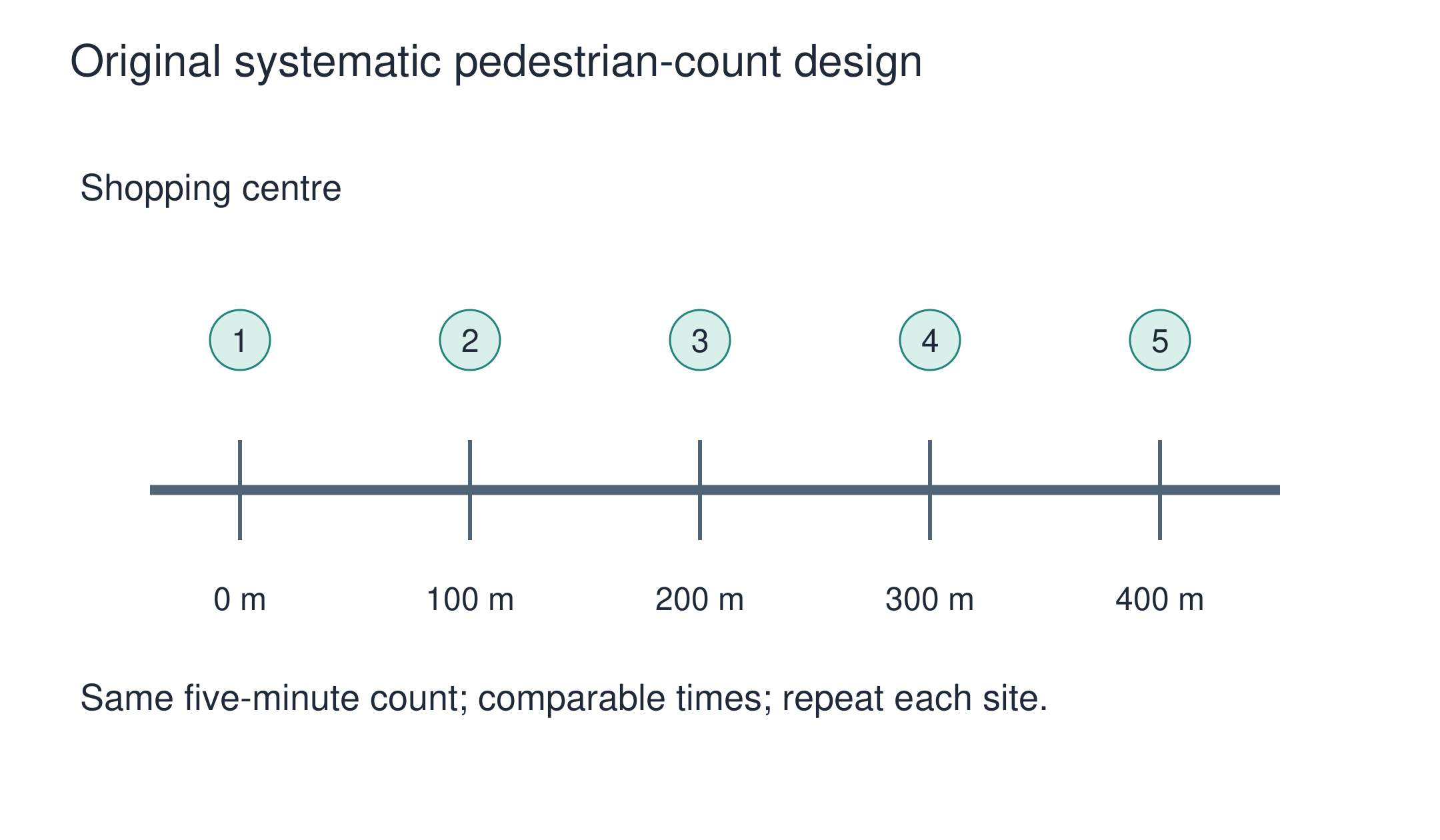
Existing original lesson representation: Original systematic pedestrian-count design. It illustrates its source lesson, not invented research results.

Original rehearsal counts at distances 0, 100 and 200 m are 30, 20 and 25 pedestrians in five minutes. Describe the pattern and improve the design.

Counts fall from 0 to 100 m then rise at 200 m; a simple monotonic decline is unsupported. Repeat comparable time windows and sites, inspect junctions/events and display the exception. These illustrative data are not IA fieldwork.

Independent transfer

One site is counted at lunch and another after closure. Why is the location comparison weak?

Attempt independently before reading the model.

Checked original model

Time and activity vary with location, so the count difference cannot be attributed to location alone. Repeat comparable time windows at each site, use consistent intervals and record events and weather. Preserve raw observations and remaining sampling limits.

These are authored formative expectations, not official IB descriptors. Accept other justified arguments with evidence and material limits.

Source and task holds

This supplement teaches the method for this part of the course. The full assessment criteria and any texts your school chooses come from your teacher.

Interactive lessons on this topic

Work through it step by step, with instant-check exercises.

More topics in International Baccalaureate · IB Diploma · Geography · SL

Log in or create account

IGCSE, A-Level & AP